Thursday, July 13, 2017

Thursday, July 6, 2017
Next Up: The Wrath of the Volcano
The ‘day’ began with us being awakened by the guides hours
before sunrise. The morning was cold and windy, wind chill well below freezing.
This night had been a bizarre experience for us both. I was awakened at
intervals gasping for breath, while Sylvia was simply cold, tired and hurting. The
darkness outside the tent was endless; though Misti looms over metropolitan Arequipa
like Olympus, we were camped on the opposite side, looking out to the north
across a vast arid wilderness. Only a few electric lights were visible, and
most of those were headlights of cars moving on a very distant highway. It was
a strange, surreal experience, knowing we were likely (and later confirmed to
be) the only people on this famed mountain that night. It was like being on the
dark side of the moon. Lightning flashed in the distance but there were no
clouds overhead; those storms were on the other side of the Andes, north over
Cusco, perhaps even Machu Picchu at the edge of the Amazon jungle.

The guide made us a light soup and coca leaf tea by headlamp
and began to ask us a series of questions. How were we feeling? Did we sleep?
Any headache? I was feeling fine, but the answer in Sylvia’s case was, not
feeling too good, not much sleep, and still plenty of headache. Angelito warned
us that what Sylvia’s symptoms undoubtedly were altitude sickness. If we went
higher, the symptoms would not get better, they would in fact grow worse. If we
had been closer to the summit, perhaps, this would not be so bad. But we had
more than 3000 vertical feet to go, five hours long hike ahead. Even though we
would be leaving much of our pack weight in camp, still we would be attacking
the thinnest, coldest air. We ate, Sylvia sparingly, and returned to the tent
to talk it over.
But I had already made my decision. If you are suffering serious
altitude sickness at 15.700 feet, it will be worse at 17,000 feet and worse
still at 19,101 feet. This climb for me was never about the summit; it was
always about testing our limits, and about the experience itself. One of us had
encountered a limit. When that happens, you must weigh the odds and decide…Push
on or let prudence take the better part of valor.

Continue on, and perhaps we might make it; but the
experience would be a nightmare for Sylvia. And the most likely outcome was being forced to turn around and stumble back to the tent by headlamp. I was
satisfied with the experience, and to take the risk of continuing to me seemed
pointless.
The argument was brief. Sylvia agreed that this was the end
of her hike; she had given her best getting to the base camp and more was not
possible. She urged me to go on to the summit alone and complete the hike, but
this simply was out of the question. I was not going to leave my wife in a tent
on a mountainside in the middle of nowhere, at 15,700 feet. There was only one
thing to do, so I returned to the guides and informed Angelito and Eli that our
adventures was over. We would not be summiting. Though we were disappointed,
this was the right decision.

Misti's sister volcano Picchu Picchu at twilight
Angelito, who perhaps had expected this, did not question
our decision. promptly replied that he would have to leave for the high ridge
shortly to go call Esteban to bring the car in earlier than expected. We would
remain in the tent to rest. He urged we walk about a bit and keep active when
we were able.
I got little rest until the sun finally came out and then,
as prescribed went out of the tent for a look see. Man, what a sun rise! I can
only imagine what the crater was like; but I had no regrets about not making
the attempt, Sylvia simply could not have done it and, for all I know, I might
have got turned around too.


The summit beckons, but from arfar
Eventually Angelito returned having successfully called the
car, and Eli followed an hour or so afterward. As I had surmised, Eli summited
the mountain entirely alone, and had the entire summit to herself; she was able
to take two pictures before her camera died of the cold. She reported the last
few hundred yards very tough, and light fresh fallen snow.
After her return we made ready to go, grudgingly abandoning
much of the water we had hauled up with us (My opinion was three liters is
probably enough unless you are doing cooking or cleaning. But then, in warm
conditions you might need a lot more. The downhill to the car too no more than
an hour and was a cakewalk, the easiest downhill ever…although Sylvia still
managed to fall once.


The car arrived at almost the moment we did and after a few
minutes spent shaking ash out of our shoes and clothing, we climbed into the
car. The day, at last, was done.


Except that it wasn’t. This ended the hiking, but began
without doubt the wildest car ride of our entire lives. Esteban, the Mad Max of
Peru, chose to take the ‘short cut’ back to Peru. This was a narrow, winding
‘road’ (Rock field would be a more apt term) the traversed the gigantic canyon
between the massive volcano Misti and it’s even more massive sister Volcano,
Chachani. This road was not only steep, but by any definition of the term,
impassible to vehicles. But this did not stop the Mad Max of Peru, who drove,
jockeyed, juked and eased his Korean made 4x4 vehicle, occasionally at walking
speed through areas a goat would not have gone. Alas, no video of this ‘road’
exist, we were too busy clinging to the seats for our lives. Several times I
did in fact strike the ceiling as the car went into an out of ditch sized
potholes. No Bolivian death road can lay a finger on this mule track.
To give you an example of how bad it was, we passed only one
vehicle the whole way…and this was bewildered mountain biker watching in dismay
as we passed.
But this was only the beginning. This turned out to the
BETTER of the two ‘roads’ we took back to Arequipa. The second was made the
first bit of rough road look like a better section of I-95.
Shortly after traversing a particularly bad section along
the edge of a cliff, twiddling the dials of his radio as he drove, Esteban
swerved suddenly onto a narrow, gullied trace that resembled a desert wash in the
hours after a flood. To our astonishment, this was his version of a short cut
to the short cut. Answering our panicked inquiries with assurances that
this was way “Muy Bonito!” he literally walked the jeep from crater to crater
along what I would generously call a roaded rut.
But all’s well that ends well, and soon we reached the man
road into Arequipa, back on blacktop again and doing the usual Peruvian dance
of swerving around cars, buses, pedestrians and moto taxes. The Mad Max of Peru
had us back in Arequipa in an astonishing 97 minutes. If only my knees hadn’t
been in continual agony the whole way, I might have even enjoyed it.
In the city we said goodbye the Angelito, Esteban and to
Eli, without whose help we would never have accomplished anything. We proved
ourselves equal to Colca Canyon, but towering Misti was too much for us. Sylvia
is even now on the treadmill with a picture of the Volcano in front of her
vowing to be equal to the mountain…next time.
But this adventure was over. It was back to Lima for us,
and then on home to Raleight. We had come for the experience, and we did not go
away empty handed.
Here’s to the kind people that made this adventure possible…the
travel company our guides, Esteban the driver, AKA the Mad Max of Peru, and
most of all Eli our guide from Colca, the only person from the expedition to
actually make it to the summit of Misti this trip.

Brian, Sylvia and the Mad Max of Peru, Senor Esteban

Us with guides Eli and Angelito

The mountain that remains elusive
And we’d like to also thank Misti and Colca Canyon for the
great challenge they presented, and will likely always present as long as there
are men and women with the will to climb them.
See our YouTube video here!
https://youtu.be/LhdYt-LJtis
See our YouTube video here!
https://youtu.be/LhdYt-LJtis
-Brian
Tuesday, July 4, 2017
Under (and up) The Volcano
While Colca Canyon was by no means an easy trek, it also
broke no new ground for either of us. Canyons, steep trails, volcanos and
multi-day hikes at elevation were all things we had done in the past, thresholds
we had crossed before. But the next hike promised to push us far past the
limits of anything we had previously done.
I knew that the entire trip would revolve around Misti. Though
not a technically challenging peak, Misti is BIG, and very exposed. Little that
grows on its ashen flanks will stop the wind. Altitude and weather are the
primary obstacles, and while we had some experience with both, this massive volcano
would demand much more. Misti surpassed by over 3000 feet anything I had ever
climbed. The night we would spend at basecamp would be the highest we ever
slept. Wind chills at the summit were consistently below freezing. I had done
big volcanos before, but they were still HALF this size. I knew that Misti lay
near the boundary of what we could reasonably hope to achieve. The question
was, what side of the boundary? The possible, or the impossible?
Could we really hike this mountain?

Misti
The early signs were not auspicious. Our guide for the Colca
trek, Eli, would be coming along with us, though technically not in an official
capacity; she had never climbed Misti. We had yet to talk to the actual guide. We
also kept getting mixed signals from the travel company about the amount of
water we would need. Was it three liters, four, five of six? Each time the
figure was mentioned it seemed to keep going up. And what exactly would the
guide do, and what would be provided and what would not? This is never a sure
bet in Peru. The tour company had promised us one thing; the guide might say
another. Much depended on the guide, whose expertise would bring us to the top of
Misti and (more importantly) back safely.
In Chivay, where there is nothing resembling an outdoor
outfitter, we attempted to do what we could to prepare. We expected to carry 5
liters of water each. This is 11 pounds in addition to our other gear. Reading this,
it probably doesn’t sound like much, but try humping it up a steep slope at
altitude. One of the main challenges with Misti is there are no water sources
at all; if you run out, you are in trouble. And you need a lot of water to
summit a big mountain in a dry climate.
We also added as many warm layers as we could, which meant
visiting the local marketplace in Chivay looking for anything that might
suffice to keep us warm. Fortunately, alpaca wool was not in short supply. We
went to bed that night not really knowing what to expect the next day. If all
went as planned, the next night would be spent in bivouac at 15,700 feet.
At 8 am the next morning we set out with our packs full of
weighty water jugs and hand-knit alpaca gear. Our driver, Esteban, who ranks behind
only Mad Max as the world’s greatest off road truck driver, met us and Eli at
the door to our hotel. The road to Misti crosses the bleak, windswept pass of
Patapama, a viewpoint from which a horizon full of sinister looking volcanos
can be observed. Here we crossed paths again with Peru’s most active volcano,
Sabancaya…this time staring directly at it while it spewed plumes of grayish
ash thousands of feet into the air. You can get a good look at it in the
picture below.

Sabancaya, doing what volcanos do. Note the cinder cone very clearly visible at the extreme right.
From here we dropped down to a truck stop in the remote
desert which presented a fine view of Misti looming like a watchtower over a
desolate plain. After drinking some coca tea, known for making the effects of
altitude sickness less harsh, Esteban roared back onto the highway for our
rendezvous with our guide for Misti, at a police check point so remote I doubt
if it exists on any map. The guide was a man named Angelito who we had yet to
meet. He was coming down from Arequipa to link up with us.

Coca Tea anyone?
But after 45 minutes he did not show, and both Esteban and
Eli began to watch the road with growing unease. We also began to feel apprehensive…he
did not answer his phone. Had he missed the message? Had his ride broken down?
Was this to be the end of our trek?
But eventually Angelito showed up, carrying nothing but an
ice axe (his gear was already in the car, having been brought up by Esteban the
night before.) He greeted us, hopped in and it was on to Misti.

It took a good hour from there to reach the drop-off point,
crossing paths with huge herds of Llama, Alpaca, Viacuna and even a few rarely
soon Guanacos. The dirt portion of the road was in good shape; the truck only
got stuck once in ash (this was in sharp contrast to the “road” we took out,
but that’s a subject for later.)

Once we had started to gear up another miscommunication developed.
Angelito expected us to carry the bulky mountaineering tent to the summit
ourselves. While not an unreasonable request, this was NOT what we had been told
by the travel agency, and all our calculations had been based on this. Burdened
under a heavy tent as well as the water and gear, I was not sure I could make
it.
But Sylvia quickly ironed things out with Angelito and he
agreed to carry the tent for us, probably cursing either us or the travel
agency as he did so. But he was polite about it, and after a short delay while
I managed to impale my fingers on what looked like grass but was more like a
weed made from porcupine quills, we were off.
Angelito had chosen the Northeastern Aguada Blanca route to
the summit (You can read a detailed description of this route written by the
blogger Rick McCharles on his website BestHike.com.) This route is considered
to be the safest and easiest route up the mountain. On the drive in, while we
stopped to view some odd-looking rock formations near the road, he had told me
this was his first trip on Misti this year. He also quizzed me about what had
brought us to Misti and what preparation we had done. Angelito seemed skeptical
of our level of acclimatization, and perhaps justifiably so. His opinion seemed
to be that a week was necessary to fully prepare for Misti, but then, with
altitude you never know.

Angelito set a very slow but steady place; imagine how you
would walk trying to carry a piano on your back. His method was go very slow, but
with no stops, and rest infrequently. There was no trail; we went straight across
dunes of black ask the consistency of Talcum powder, interspersed with tufts of
the porcupine grass. Nothing blocked the wind; when it whipped up, it lashed
our faces crosswise like sandblasting. It was step, step, step, slide backward
and step again.
At the 45 minute mark we stopped for a break, and then again
at about the 90 minute mark. By the second break, which was also the last,
Sylvia was clearly struggling. I had hit my stride, but Sylvia was stumbling
forward awkwardly, reeling from altitude and the heavier than expected pack.
By the time we reached the windswept ridge of the final
approach I was shouting encouragement to Sylvia with virtually every faltering
step, urging her onward toward the rocks that marked the camp. The howl of the
wind grew higher and my slogan shouting became drown out beneath it. But we had
made it finally. I was little worse for wear but Sylvia was exhausted and
quickly went into the tent that the guides had just finished setting up. At that
point, I was entirely convinced that with some rest Sylvia would recover and we
would summit. I pulled out the GoPro for a quick filming of the remarkable
sunset, and then dove into the tent myself to get as much sleep as I could. Angelito
had already stated that most people don’t sleep much at 15,700 feet.
The fun would begin at 1 am when we would be roused for
breakfast/dinner followed by the summit attempt, with us arriving at the summit
in time for sunrise.
See our YouTube video here!
Next Up: The Wrath of
the Volcano
Sunday, July 2, 2017
The (3500 foot) Wall
There is no way out of Colca Canyon except by walking. There
is no vehicle road to the bottom, no helicopter service, and no elevator. To
escape you must climb the wall…either under your own power, or the on the back
of a mule obliged to do it for you.
We chose to walk, and arose shortly after 3 am to prepare
for our exit. In mountaineering terms this is known as an ‘alpine start’, since
most assaults on technical mountain peaks begin in the early hours of the
morning. The plan here was to beat the heat and arrive on the rim for
breakfast. We would climb on a mostly empty stomach.
The night was still absolute, the electric lights in the Hostel
having mostly been turned off some hours earlier. Around 4 am we met out guide
at the foot of the trail; since Eli had decided to depart an hour earlier than
most to give us extra time, most of the other hikers were just awakening.
We moved slowly up the trail by headlamp and starlight. All
we could see below were a very few scattered lights in the oasis; the rim was a
shadow above. It was a rocky climb; unlike the trail we had descended this one
had a lot of switchbacks and high step downs. Eli had told us this was not a
particularly good trail for descent, and from what I could see (which was
basically right in front of me) she was right.
Soon, snaking trains of moving lights appeared on the
switchbacks below us. The hikers were beginning their exodus. The first to
overtake us was a local guide in jeans and a t-shirt going at a pace that would
have killed an unacclimated man; not far behind him came the first tourist,
some ultra-sport athlete with something to prove. Many followed. I was
surprised how many of these hikers eventually overtook us, since we had a one
hour head start on all of them. Of course, the majority were some number of
years that starts with a 2 younger. But almost all of them were sweating,
breathing had, tired already and in general racing for the rim like sprinters.
Sylvia and I, moving slower, were barely winded. Had the hike gone on another
day, we probably would have past all but the strongest, just as happened at
Salkantay and Punta Union a few years back.

Eventually the sun came out and I got out the GoPro and
started filming, but the trail was becoming increasingly crowded and there wasn’t
much to film; the ascent trail is more closed in than the descent. We did see a
large hummingbird, and far across the canyon, the bus from Chivay winding its
way along dirt roads we had walked the day before. Soon, trains of mules began
to pass us, some of them carrying worn out hikers (of those who perhaps had indulged
in a few too many Mojitos in the Oasis.) We had our eyes set on a clump of
trees that marked the top. It came closer, but slowly.

This last pitch is the hardest since the elevation is now
over 10,000 feet. But at last the objective was in sight and we could hear
hikers cheering the arrival of their friends. Then it was us being cheered…we had
arrived at last! Finally, here was the panoramic view, with the same whitecap peaks
of the Cordillera Chila peaking above the far rim. We had come back almost to
the same place we had left from.


But not quite…after a few pictures we had to walk the mile
or so into Chivay to our restaurant, at one point walking down an irrigation
ditch ankle deep in water. It seems all trails in the Colca area double as
Aqueducts. But eventually we did make it, and enjoyed a much-deserved breakfast,
watched all the while by a forlorn looking dog.

Example of a forlorn looking Peruvian dog.
After this, it was onto the bus and back to Chivay.
We had completed our three-day traverse of the world’s
second deepest canyon, but then we had expected to succeed. Our adventure was
not done, and it was anyone’s guess if we would have the same success in the
next place as here. For on the horizon, quite literally, was Volcan Misti…one
of the highest walkable peaks in the world. Tomorrow we would be headed there.
I had my reservations, but we were going forward.
(An interesting postscript…on the way back from Colca we
stopped to rest for an hour at a local hot spring. There, I noted a cloud
rising over a ridgeline. This turned out to be the ash plume from Sabancaya,
Peru’s most active volcano, erupting almost continually for years now. The
cinder cone was just ten miles away. We captured the cloud on film.)


See our YouTube video here!
https://youtu.be/CvZwfnxs0G4
Next Up: Under the Volcano.
Saturday, July 1, 2017
Walking Along the Colca
I was awoken the next morning at 4:45 am by someone yelling
outside the hostel…I figured it was some local yelling at a stubborn burro or
lost chicken, dismissed it and went back to sleep. A couple hours later, it was
time to rise for real and get breakfast. The rom had been reasonable; though
rustic, it was better than sleeping in a tent, and the bathroom despite its
lack of hot water was still a lot better than a hole dug in the ground. We
wished for an electric light, but changed our minds about that the next night.
This day’s hike promised to be relatively easy. Though we
would follow the river, we would be above it…first climbing moderately to pass
through a pair of villages (Cosnirhua and Malata) before descending, again at a
mostly moderate grade, to the final crossing of the Colca river and on the
Oasis of Sangalle, located in a broad bowl at the river’s edge. Sangalle,
somewhat famed as a resort, would be our destination for the day, and the place
from where we would launch the ascent of the canyon wall on the last day.

The glaciers in the background belong to the Cordillera Chila. Not one peak in this range is less than 18,000 feet high.
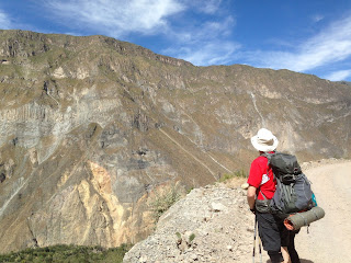
This was scenically the best day of the hike and we hiked
across the canyon’s north side, down a slot canyon, over a stream crossing via
a rickety bridge (if you were brave like Sykvia…chickens like me just hopped
the stream) and then along a road that become a narrow mule path with
outstanding views. The north side is the more inhabited, but higher up it is
wild and rugged…there is only one sketchy dirt road plowed through the hillside
as far as Tapay, above Cosnirhua. Looming above these tiny havens is rough,
uninhabited country…the white capped peaks of the Cordillera Chilla and the
otherworldly landscape of the Valley of the Volcanos. Almost unsettled,
sparsely travels and not connected by any major roads, these area are formidable
wilderness challenges not lightly undertaken even by a guided hiker. While
staying in San Jaun de Chuccha, we met a French hiker who spoke little English,
travelling alone, on his way to the falls of Fure some three days hike further
along. Our guide expressed dismay that he was attempting this daunting route by
himself; we have no idea to this day what became of him.


If you think the bridges in your hometown could use maintenance, try this one!
Speaking of lost adventurers…while resting in a small market
we met another pair of French hikers who arrived breathless from a climb out of
the valley and told a strange tale. It was they whose yelling had awoken me in
the early morning hours. Apparently, they had gotten lost and the sun had set
on them before they could find their way to safety. They spent a cold night in the open by the
river’s edge, and had come in towards the lights of the village as soon as it
was light enough for them to walk. They had called the police in desperation, but
had been told there was nothing the police could do for them; they would have
to wait until morning. By the time we crossed paths with them, they had
effectively self-rescued. It was reminder that in the remote areas of Peru,
there is virtually no possibility of evacuation, unless you pay for a horse to
do so. The helicopter isn’t coming, so if you want to do trekking here, be
prepared to walk yourself back out to safety. We left the French couple in the
center of the village, waiting for the police to come back from patrol, and
continued on.


Past the villages of Cosnirhua and Malata along the only
dirt road in the region, down which a bus winds its way once per day. Then via
a narrow burro track down along an arid plateau that appears to be extinct
farmland; here, we stopped at a trailside market run by a friendly local man
who assured us he was “popular with the French girls.” I assured him in return
I was popular with at least one Peruvian girl, most of the time anyway. After
the market the trail turned steep again and we descended to the final crossing
of the Colca; here, we got our first glimpse of Sangalle, the tourist oasis
where virtually every visitor to Colca Canyon eventually ends up. The only
caveat is, you must walk to it…and you must walk out again, too. No easy thing,
this.



Before Sangalle though we had to pass yet another suspension
bridge and this one was five or six times higher than the first…a spectacular,
if unnerving vista from which to observe the canyon. After this it is a short
hike uphill to the Oasis, which looks more like a spring break resort than the
wilderness hiking mecca. Blue swimming pools and tiki bars proliferate here, as
mostly tired hikers pile in at the end of each day to lounge by the pool, enjoy
Mojitos and beer served by shockingly rude bartenders (it’s a long hike to the
next saloon) and in general relax and enjoy before leaving the next morning.
The majority of hikers are college age Europeans who do this as a two day trek;
for these, the Oasis is their first nights destination.


Here we spent some time talking to a couple from, shockingly
enough, Durham NC. And another couple who we kept seeing at every stop on the tour,
these two being from Tenerife in the Canary Islands. They had apparently been
on vacation for months, hiking around the world and had done world class treks
in Bolivia, Patagonia, Spain and Africa before coming to Peru.


Accommodations here were rustic, maybe slightly better than
Roy’s or maybe not, depending on how you looked at it. There was running water
and showers but bathrooms were shared, and while each hut had an electric
light, what it lacked was a wall capable of keeping the insects out (picture
the hut Gilligan and the Skipper shared and you’ll get the general idea.) We
slept, or tried to, with moths attempting to land on us all night. And at least
three times during the night, the entire canyon exploded with the barking of
scores of dogs, two of which decided to bed down right outside our door. I
would mark this the less comfortable of the two nights, and we also faced a
very early ‘alpine start’ the next morning to beat the heat of the canyon wall.


NEXT UP: The (3500 foot) Wall
See our YouTube video at:
Friday, June 30, 2017
The Long Walk Down
Arriving back at Chivay after the condor trip we prepared
ourselves for three straight days of hiking in the canyon. The little pavilion
at the start was mobbed with hikers; even though our tour consisted of just
myself, Sylvia and the guide Eli, many tours start from here…serving as a
reminder that Colca Canyon is Peru’s 3rd biggest tourist attraction,
getting over 100,000 visitors annually. A lot of people, but then Grand Canyon sees
fifty times that many. Here as well is the ubiquitous Peruvian kiosk with
bottled water, soda, snacks and hiking poles for sale. And a last-chance restroom
with a manual-flush toilet (it’s called a bucket of water)…you could use it for
the price of one sol (about 35 cents.) Beyond this, even bushes to hide behind
would be in short supply.


Soon we were underway. It was barely mid-morning, maybe
about 9 am. Some of the best views are those had early…sweeping vistas up and
down the canyon. Again, comparing this to the Grand Canyon, Colca is not only
deeper but much more precipitous…unlike the Colorado River which is miles from
the rim and usually hidden from view beneath ledges and plateaus, the Colca River
is entirely visible for those who dare to look straight down. This means that
the downhill is much steeper, but also relatively fast (it takes half a day of
hiking to reach the Colorado from the rim…a fast hiker can reach the Colca in
perhaps three hours.)


As we walked, the entire hike unfolded right in front of us.
This is one of the odd things about canyon hiking…from the start you can see
everyplace you will go, often surprisingly close at hand. But once you get
deeper into the canyon, the landscape swallowers everything. Now, all you can
see is what the bending and twisting terrain will allow you to see, which is
often as not deceptive. We had a brief glimpse of the Oasis, our second days
destination, as we turned a bend. We would not see it again for over 48 hours.

While it was steep, the downhill is not especially
difficult. There was only one section that I would consider dangerously rough,
and this was very short (less than ten meters.) There were a few sections that
pass under rock ledges, and these tended to be the rougher ones, and the guide
urged us not to stop for long in these areas. But we saw no rockfall. The
biggest threat was the sun…there were almost no shaded areas on the south side
of the canyon at all…there are no trees except for one clump at the very start,
and what few shady spots there are provided by folds in the canyon walls
themselves (the microclimates of these little oasis are shockingly cool.) But
these are few and far between; mostly, this is a long way down along a trail
that is continuously in bright sun. As you get closer to the bottom, it gets
hotter. And there is no water at all between rim and river except what you
bring. By the time you gratefully reach the Rio Colca, it is obvious why an
early start is considered mandatory on the ascent.


The river is crossed by means a large and impressive looking
suspension foot bridge…which like all suspension bridges shakes alarmingly when
crossed, but seems safe. After resting in the shelter of a boulder we turned
sharply uphill to scale the river embankment, the first climb of the trip.
Fortunately, elevation is not as much a factor at river level as on the rim.
Eli the guide detoured us through a rough, jungle-like section to reach the
final stop of the day; Roy’s Lodge in the village of San Juan de Chuccho.


The contrast between the barren south side of the canyon and
the cultivated north side could hardly be greater. While not a tree stands on
the sun-baked south wall, the north is not only lush but populated.
Agricultural terraces shaded by orchard trees line the hillside, supported by
systems of well maintained aqueducts. Villages dot the hillside in abundance.
Crossing the river one leaves a starkly beautiful desert hellscape and enters a
place that can truthfully be called a paradise, each separated by a moat of
water perhaps twenty yards wide.


We sat down for a fine lunch at Roy’s, where we had a view
of the canyon wall before us, and the lower part of the trail switch-backing
down it. We were done for the day but some tourists were still making the
laborious descent, in full view of us and in the full heat of mid-day.


After lunch and a tour of our accommodations (private cabins
which included bathrooms, but no hot water and no electric lights) we went out
for a walk with the guide. The abundance of foodstuffs growing here is
incredible…pumpkins, figs, dates, avocados, various kinds of fruits and of
course the staple of the Andean peoples, corn. Sadly, we also learned from Eli
that the villages we saw are mostly metal-roofed derelicts. Despite its
lushness, agriculture beyond the subsistence level is impossible in the canyon.
You can grow food, but you can’t easily get it out of the canyon to market.
With few opportunities for work or schooling, the young people of the villages
are leaving for the cities. Those that stay are mostly the old, and those (like
Roy’s family) that support the tourist infrastructure. In a few years, the
culture will be entirely gone. Only the hotels and empty buildings will remain.
See our video here!
Next up: Walking Along the Colca
Subscribe to:
Posts (Atom)