Tuesday, July 28, 2015

July 11 2015
Santa Cruz Trek Day 4
The Final Day

The last day of our hike is here!

I emerged from the tent to clear blue skies and three freshly deposited cow turds. Folks I will say this up front…if you have problems will animal manure this is not you hike. I’ve said the necessary so let’s move on.


 Sylvia is ready to go on and fight shy of this place, as they say in Texas.

On the other hand if you love hikes with staggering views in plenty than no hike could be better, and we had them every day of this hike…this one not accepted. Sylvia, feeling an intense desire to be in the land where toilets were porcelain bowls that flush and hair driers are available, was very keen to get going. Some people! Our guide Freddie informed us that there would be no detours this day…there was only one way to go, and that was down. The estimated we would be finished by about noon. Which of course did not mean being home by any means, we were still a good two hour plus drive from Huaraz which is not exactly Malibu Colony…


Who wants to do some more hiking? This guy!

Right away the downhill go intense. The valet of the Santa Cruise River quickly narrowed and became a gorge, through which the river tumbled in a seemingly endless series of cataracts. We were going down fast but the river was really plunging. The trail wound along the leftmost edge of this canyon…the views above constricted until we could no longer see white capped mountains, just the rugged sides of the rock towering above us, and the wedge of sky overhead. Speaking of sky some weather had moved in behind us from the high peaks and it looked, for a while, like rain might overtake us. But ahead was clear blue and that was the way we were going. The rain, if there was any, never did catch up.


This was a step, at times ridiculously steep, trail. Every time we passed somebody (or some heavily laden mule) laboring up I felt sorry for them. I was not happy to be walking down this slope on my Herman Munster-John Kerry like knobby knees, but I am sure glad we did not come UP this way. The incline seemed never ending. Good choice by the guides to go THIS way. Most itineraries do the opposite.

And the slide zones were crossed…every quarter mile or so another one, some older with moss covering boulders and others seemingly having happened overnight. Some of these were gravel, others sand. There were some dicey bits her particularly when the trail went around blind corners, but we kept moving without mishap. I did stumble a few times. Sadly, pictures of me shuffling downward are not available here (even if I was stupid enough to post them) because there were taken by Sylvia with her Iphone. I am sure she will post a profusion of them eventually.


We hiked a good two hours like this, and while it was hard on the knees, one good think about going down is, you go fast. Sometimes the river ran right beside us, and sometimes it was two hundred or more feet below us. Always it seemed to be running away.


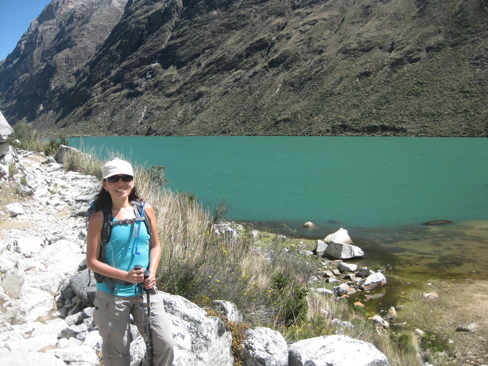
The valley becomes a gorge, above. Below, me posing as I rest my knees on the steep trail. 


And then around the bend the valley opened up and there beyond lay the destination…Cashapampa, a dot on the map of the Andes but it was where we needed to go. We steadily watched it approach with mixed feelings. I was tired and ready to be done and go ice up my knees, but I also wished to be back in those mountains for one more day…would another day with the Alpamayo, with Santa Cruz, and with gleaming Huascarin be so bad? But it was not to be, civilization lay ahead. Sylvia’s feeling were shall we say less mixed. She was also missing the views but what she really wanted was a view of a real bathroom.


Soon enough we were there. We passed through a livestock gate that led under the town’s aqueduct, which we then walked beside for a while. We were now back in farm country and on each side of us were fields of potatoes, wheat and Quinoa. Soon we saw a shrine up ahead of it and to the right a Ranger Station. Here it was at last! Cashapampa, the end of the trail.


Most people actually begin the hike here and go in the opposite direction, and so there is a sign here, outlining the hole hike. Sylvia and I posed with it. Dear it we saw another sign, this one not official…it read, “Stay here drink beer.” This was a statement dear to my own heart, but I was not quite ready for a Cusquena yet…once we were back in Huaraz, then I would indulge.


We reached the bottom of the hill where there was a friendly store. The guides did in fact sit down for a well-earned beer while we had cold water and, to my great astonishment, an ice cold Coke. (Coca Cola is not rare even in the Andes, but what they usually call cold is what I might generously term luke warm.)

Sylvia also made another finding…There was a toilet! True it was out back in the middle of a field behind a construction site, and like many Andean toilet it was curiously lacking a seat, but still it was an extravagance compared to what we had been seeing. Sylva pronounced this the greatest crapper ever.

After this was out of the way Oswaldo our tour arranger showed up with the car. Me, Sylvia, Freddie and Edwin piled in for the journey out. This road was not quite as steep or precipitous as the one inbound but…it was still pretty damned nerve wracking. There was a lot more traffic on this road, and all of it seemed to pass us just as the car turned into a blind corner, or in a narrow stretch between adobe walls where seemingly just one car could pass. Peruvian drivers have an unusual method of dealing with these situations. Both drivers simple continue heading straight for one another. At the last minute, somehow both cars miss, and both drivers continue on without any visible reaction. 
At one point, we had to back up and let a gigantic ten wheel truck go by. As the truck slid past just a hair’s breadth from the window I saw, incongruously, that the driver had stenciled one of those family logos you see on minivans to the side of the truck…daddy, mommy, kids, dog cat.

Oswaldo skillfully had us down to blacktop in about an hour and then it was yet another hour to Huaraz…stopping for ice cream along the way. I can only express tremendous gratitude to him, and to Freddie our guide, to Edwin our cook, to our mule driver Ariero and to Sylvia, above all, for putting up with this. How many women who are not exactly dedicated hikers would have parted with running water and bathroom facilities for most of four days? But even she agreed the views were worth it.

This sort of trekking is not for everyone – though in my opinion, anyone who is reasonably healthy could do it. The challenges and obstacles are mental as much as physical. Travelling in Peru is exhausting and takes a great deal of patience, and sometimes things do go wrong, but the rewards are obvious. We did what we set out to do…we hiked in the second highest mountain range on earth. It was everything I ever wanted to do. And I did it with the person I love most.
What ending could have been better?


(And yes the hot water in the hotel worked for a change.)


Monday, July 27, 2015

July 10, 2015
Santa Cruz Trek, Day 3
The Santa Cruz Valley

Upon arising for the third morning I was greeted, as I stuck my face from the tent, by a cow. The cow, standing about twenty feet away, took one look at me and beat a hasty exit, stage left. I can only imagine what went through its bovine mind; the image of me crawling through the opening of the tent had probably convinced it that some alien jellyfish had given birth to an even stranger humanoid hybrid. Whatever, I was up, and it was a beautiful day for hiking.


The Alpamayo beneath one of those weirdly beautiful cloud formations that are dime a dozen on Andean mornings. 

It had not been nearly as cold a night as the last by my standards, but despite this, and despite the presence of hand warmers, Sylvia once again could not get her feet warm. Perhaps just as I need new knees, she needs new feet. We breakfasted, had coffee, and filled our water suppliy with quality H20 kindly boiled by the guides the night before. We got more snacks (more than we could deal with, actually) and we were ready to go.


Freddie the Guide told us that we had two options for today, basically….we could hike for six hours, which was flat, and have great views, or we could hike a short distance uphill which would take us maybe an hour out of the way, at most, and have greater views. A nights rest had done wonders for me (as had that foot bath in the mountain stream) and Sylvia, chilled as always, was looking to warm up. We were feeling chipper. We opted for the scenic route.


Redecorating, Andean style...Views of the mammoth slide zone. First, where it originated, and second, where it ended up. 

This trail was sketchy in places, little more than a goat path, but Freddie knew what he was a about. In no time we were standing at the gates of the Alpamayo – which is not only a cluster of peaks but also the name of another hike in the area much more intense than this one. Freddie said that two more hours of this would take us to the base camp by which serious mountaineers attempted the Alpamayo and Santa Cruise Peak. This Trek is NOT for the faint of heart…it is longer, it is further, it crosses multiple mountain passes, and it is colder. Are there as many flush toilets on that hike as this one…zero.


We each take a turn posing with the Alpamayo, considered one of Peru's most scenic mountains...and a challenging trek of its own.


Look familiar? This mountain, Artesonraju, is reputed to have been used as the Basis for the Paramount Pictures logo. Imagine it with stars circling overhead...

We soon started down, and on the way out passed a mule train and some hikers that were in fact returning from the Alpamayo. They passed by us, and we stopped to rest in a wooded campsite near the river. This campsite bordered on the edge of a titanic landslide zone that, a few years back, buried the entire valley in snow, rock and mud and wiped out two picturesque mountain lakes. It also killed numerous cattle whose bones can still be seen strewn about everywhere. The destruction is the most complete I have ever seen, surpassing even that which I had seen in Mt. St. Helens in 2008…but of course, that was almost three decades after the fact while this was recent.


The area behind the capering yutz in the upper photo shows the area where the slide came through just before it hit the valley. In the lower, the only train that runs in this range of mountains.

We crossed this area of destruction, which was like walking on a fine sand beach, for hours. Sometimes the trail was right on the washed out area and sometimes beside it. It went on for miles, proof of the terrible power of the slide. Finally, it petered out and we came to the last remaining untouched lagoon or lake. Here we had lunch. Some of the surviving Isreali kids caught up with us and stopped for lunch too. Freddie told us the story of a young woman who he’d had in his group a couple years ago who had collapsed from fatigue near Punta Union, and he’d had to bodily carry her up the mountain…where the views magically revived her. He also told us he liked the pace we were going at (despite my knobby, John-Kerry like knees) and that the most fit hikers he’d ever met were inevitably Austrians. It was hard to be a guide for Austrians, he said, because they can hike all day and never stop.


Most of the rest of this day passed without incident. It was a long, but easy, day of hiking. We passed the ruins of two abandoned bathrooms (the National Park administration apparently does little to maintain anything here) one deserted village, probably abandoned on account of the slide, and one or two very large hummingbirds…blackbird sized. At was no shortage of views, including several amazing waterfalls…sometimes appearing on both sides of the trail at once, as glaciers to either side of the trail melted. All the previously day, while we had been our tent, we’d heard the rumblings and cracking of icefalls from the glaciers and ice fields above. But that ceased with the coming of night.


Ghost village...nobody home. The building on the left, sadly, was once the banos. 

We crossed a spring of ice cold water that issued from one of these falls…coming as it did from the high country, Freddie pronounced this the only water source along the whole way that was fit for drinking. I didn’t chance it though…what was fit for a Peruvian guide might not be fit for Gringo Grande. There was no telling what was upstream, could have been a dead cow 100 yards away. So we settled for dousing our hats and cooling off a bit.


The campsite soon hove into view…I think this was Llamacoral or somewhere near it and it was a nice spot, right by the river…but alas the cows and mules crowded in here too. Also as I gave myself a foot bath for the second time, some flies the size of pterodactyls took enormous bites out of my leg. I’d been bitten by a similar fly in the high jungles near Salkantay…they were like black flies by six times bigger and left bloody, circular welts.


With the guides, Freddie and Edwin, we enjoyed our last dinner of the trip. We were told tomorrow’s hike was all downhill and we would be out in a matter of hours. Sylvia, suffering separation anxiety from her hair dryer, was clearly looking forward to this. But I had mixed feelings. This was exactly what I had always wanted to do, and while I was tired, I couldn’t but wish for just a few more days exploring these majestic mountains.


The Last Camp.


But we still had one more day of hiking, and this would test my knees quite sorely…and yes that’s a pun.

Sunday, July 26, 2015

July 9,2015
The Santa Cruz Trek, Day 2
Punta Union

We awoke the next morning to the sound of the guides already up and busy about the camp chores. Sylvia had, as she often does, suffered the whole night from cold feet. We had brought a pair of hand warmers for this but, considering the next campsite promised to be colder, she was saving them for it.
The guides helpfully provided us a basin or warm water for washing, which I took to the most poop-free area of the camp so we could 'use the facilities.' I had already ‘tested’ the latrine that morning at 5:15 am and found it in good working order, as holes go. I was ready to hike. Sylvia was simply ready to get going.


What we saw from the tent at first light. That is where we are going.


The 'powder room.' 

The way ahead was clear…up the long arm of the ridge ahead of us and then steadily higher until we crossed the spine of the Andes at Punta Union. This figured to be the hardest day of hiking. This figured, really, to be the whole hike.

With the coming of the sun alpenglow broke out on the snowfields above, dazzlingly. The views experienced this day cannot be described in sufficient terms, nor will any photograph do it proper justice. Language and technology fails here. I can only say that there was no part of this ever changing landscape that in any way disappointed. Every few minutes brought stunning new vistas into view, and as we went higher, the more we saw.


As we traveled through the high valleys we could hear the echoes of the mule drivers cries as they called to each other and to their animals. The grass and scrub here was higher and wilder…no grazing cattle now, only the passing mule and horse trains and the human traffic they supported. Freddie kept us going, slowly, steadily, choosing always the best and least eroded routes.


At last we arrived in a great cirque surrounded on all sides by peaks and glaciers, some quite close, and filled with lakes of that strange turquoise color one sees only in mountain tarns and tropical lagoons. The locals do, in fact, call these high lakes lagoons…we paused by one to rest, our last major rest stop before attempting the pass.


The approach to the pass and the 'lagoons.'

And there it was above us…a small notch in the rock atop an impossibly high wall that loomed before us. Freddie said, an hour or maybe longer. It seemed like forever would not be long enough to surmount that, but then we noticed mule trains switch backing down the grade…it was not so steep as it appeared. And it brought to mind Glen Pass in the Sierra Nevada which I had done last year…which had looked, from the bottom, like an impossibility. But in fact it took just forty five minutes of invested sweat to conquer.


You can see a glimpse of the pass just above the guide's head in the photo above...a sliver of a notch in that mighty wall of rock. Note the ravine to the right which New Englanders might compare with Huntington's Ravine.

We began the assault. Right away I knew this would be more difficult than Glen Pass. More difficult, even, than Salkantay. Not only was the elevation and the thin air problematic, but the trail was quite steep, often over slabs of rock. This was not the even, modest switchbacks of Salkantay.


But we labored up, buoyed by the views which were incredible. We were eye level with glistening glaciers that seemed to beckon at arm’s length; and slowly the spine of the Andes, with its peaks beyond counting, rose from behind closer ridges which had hidden it. We were both going into new country, Sylvia and I.


Above, our guide Freddie and cook, Edwin. Below...us. 

As we approached the final switchback Sylvia, whose stomach had been acting up all day, began to waiver. I encouraged her forward and we stumbled along. Freddie patiently set a slow deliberate pace, and I kept Sylvia going with frequent slogans and other propaganda designed to raise her spirits (“There’s the pass love, it’s not as far as it looks!”) And it wasn’t far, really, only it wasn’t close either. But it kept coming closer…we could see an imposing and well-built rock stairway that turned up and into it, giving it a formidable, castle-like look. Soon we stood at the bottom of this stairs, looking up through a portal in the rock.


We paused for a break and some pictures. Did we have enough left in the tank to make it? Sylvia looked spent but I was certain she could…a few more feet and it was all downhill. And so she looked up at the shaft of daylight in the granite that loomed above, put her feet forward, took a few steps, then a few more…and she was through!


Sylvia's courageous final assault on the pass.

Now it was my turn. I knew that on the other side was a view that was beyond anything I had yet seen. I wanted to come charging through at all once and see it. And so I took ten running steps and, without really thinking it through, ran up the slope and out through the pass…


The other side of the mountain.

What a view! It was beyond anything I had ever imagined, and no photo that we took and no photo I have seen from anyone else captures the full effect of the view from Punta Union – Union Pass. Ahead, a river valley stretches away toward distant lakes. To the right is a bright glacier, almost blinding in the sun, stretching upwards for thousands of feet…below it is a lake of pure blue, stark against the gray rock. And to the left are arrayed jagged peaks like the fangs of some extinct beast. It is an overwhelming experience to burst through and be confronted with this view, so suddenly. It is as if the world has turned upside down. Like some door on another universe of greater possibilities, thrown open.


There is a sign and here we took obligatory pictures. On the rock near the sign someone had lain the jawbone of an unlucky mule…I think it was Hercules who went to battle and slew men with the jawbone of an ass? Well he wasn’t here but, seemingly even more unlikely, there was a dog begging for scraps in this windswept place. We took our pictures by the sign and then sat for a well-earned rest. Edwin, our intrepid cook, had arrived before us with a pot full of food. This was welcome.
I spent some time filming and looking at some strange birds I saw in the pass, possibly Kites of some kind, and then it was time to move on. What else was there to do but go down? So we set out, downhill.


Top...we pose with Freddie our guide. Middle and bottom, Sylvia poses with the Andes themselves.

We descended first to the level of the crystalline blue lake we had seen from above. Even this was a ridiculously long way to go; but long before we reached this we had our first view of the campsite in the distance, a scattering of colorful dots that could only be tents along the river.. It looked tantalizingly close, across a lower plain which looked tantalizingly flat. But if hiking has taught me one thing (other than that falling face down on rock is an undesirable thing to do) it is this: Things that look too tantalizing to be true from a distance probably are.


The downhill was steep, rough and tiresome. The nature of the trail continually changed, first dirt switchbacks with high step-downs, then rock, then a slope of fine, shifting sand, and then a loose scree and back to dirt again. For me with my knobby, John-Kerry-like knees it was quite agonizing at times; Freddie the guide had stated the day before with some understatement that he noticed I ‘struggled a bit with the downhill.’ Basically, on the uphill I am okay, just any other middle aged hiker. On the downhills, thanks to bad knees and poor balance, I turn into Herman Munster. But, this is not new territory for me; I managed to avoid disaster and we made it through the descent without any mishaps.


It was on the way down from the pass that we passed the stumbling, zombie like cadre of the euro-isreali youth hiking group. Several of these hikers were clearly shell shocked from altitude and fatigue and were just staggering forward. One poor guy was being helped along by his girlfriend…at least I think it was his girlfriend, else this woman was a saint. You do NOT want to blow a tire in the Andes, folks…ain’t no helicopter coming if you do. On the sloping plain below below we passed a guide coming the other way with a pair of horses. These were, as it turned out, to rescue a couple of the worst of the young people who had come to the end of their limit. They weren't the only people we saw that day being shuttled about on four legged ambulances.

We eventually reached the plain that had looked tantalizingly flat from above. As I half expected, it was actually a fairly moderate slope…downward still, nothing big under normal circumstances but by now my feel had swelled up to twice their normal side. I trudged forward in mummy like fashion, in increasing amounts of pain, following Sylvia and Freddie. Not much further, I was assured, not much further. But of course, it was.

Soon we did reach the outskirts of a fairly sprawling campsite strung out along the river…people.mules, animals milled around like actors on a movie location waiting for someone to yell ‘action.’ Not surprisingly, our camp was one of the furthest in…Freddie and the guides deliberately picked sites that were remote and gave us a head start to the next day’s hiking.


But the next day was far from my mind at the moment. We stumbled into camp and nearly collapsed. We were out of water and exhausted; Sylvia’s stomach hurt and my feet ached. I went to bathe my feet in the nearby stream while Sylvia crawled into the tent to rest. The foot bath was AWESOME (if you ignore the bones of the dead cow that was down by the stream bank…I did.) Just what the doctor ordered….the water was so cold I could only hold my feet in for maybe 25 seconds at most. But by the time I got back to the tent, Sylvia was shivering (it got cold real quick.) We were suffering from dehydration and had no water left.

Fortunately the guides came to our rescue…they gave us hot tea by the cupful. This restored Sylvia’s juices to the point where she could come into the warm kitchen temp and eat something, while I drank cup after cup of tea and hot cocoa. When we went to bed that night, Sylvia with her hand warmers stuffed into her socks, we knew we had accomplished something. We had survived the hardest day of the trek and now, we knew, the rest was all downhill. As I looked at the night sky outside the tent that night, and the Great Sky River above me, I knew that this was what I had always wanted to do.


But we weren’t out yet. Punta Union was past, but two more days of hiking lay between us and civilization…